Earthquake Damage Level Estimation using Earth Observation and Machine Learning
- Sponsored by: TUM Chair of Data Science in Earth Observation & German Aerospace Center (DLR)
- Project lead: Dr. Ricardo Acevedo Cabra
- Scientific lead: PhD candidate Jeremy Eudaric and Dr. Ridvan Salih Kuzu
- TUM Co-mentor: Jona Klemenc
- Term: Summer semester 2025
- Application deadline: Sunday 19.01.2025
Apply to this project here
Abstract
In February 2023, Southeastern Turkey experienced a devastating series of earthquakes affecting 11 cities and impacting approximately 15 million people. More than 250,000 buildings were damaged to varying degrees across a vast area of 108,812 km², comparable to the combined size of Bavaria and Baden-Württemberg. The scale of the disaster made rescue operations and the prioritization of affected regions challenging and time-consuming. Given that rescue efforts are time-critical, integrating Earth Observation and Machine Learning presents a promising approach to enhancing resilience in the face of natural disasters. This project aims to automate damage level estimation using remote sensing imagery, SAR interferometry, and machine learning-based classification and segmentation algorithms.
Methodology
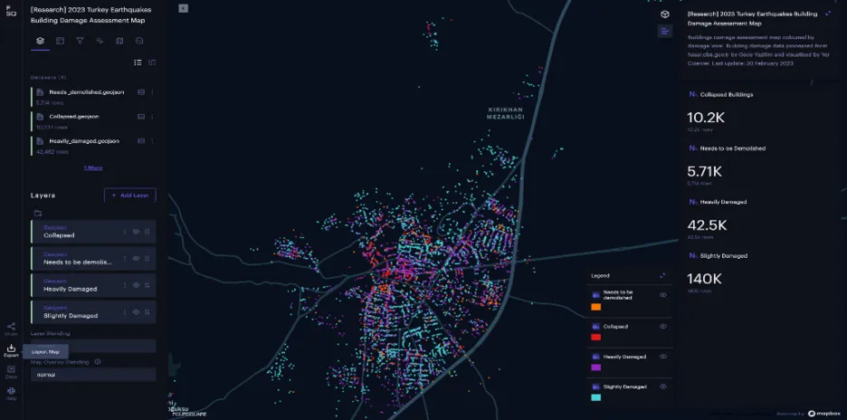
Data Curation: The project involves curating data by pairing damage reports from the field with corresponding pre- and post-event satellite observations. (Figure below shows a subset of affected area). Additionally, pre-event building footprints will be fetched from global building footprint services such as OpenStreetMap to distinguish buildings from other landmarks. This dataset, composed of approximately 200,000 building locations with four damage categories, will be converted into an "Analysis-ready Data" package to facilitate smooth machine learning training and validation.
Model Development:
Optical Remote Sensing-based Model: The model development entails two consecutive architectures. The first stage focuses on automatic building footprint detection, while the second stage involves classifying building damage levels within the detected building footprints.
InSAR Time Series-based Analysis: This technique will be used to analyze the InSAR-based displacement time series data composed of around 300 time points per building (provided by the project mentor) to estimate the correlation between pre-disaster ground displacement and the level of damage sustained. This analysis will help determine if buildings with pre-existing issues were more severely affected.
Project Plan
Task | Weeks | Description |
Project Initialization and Data Collection | 1-2 | Team briefing, role assignment, collection of pre- and post-event satellite imagery, and building footprint data from OSM. |
Data Preparation | 3-4 | Pairing field damage reports with satellite observations, converting datasets into analysis-ready formats. |
Model Development - Stage 1 | 5-9 | Development and training of the building footprint detection model. |
Model Development - Stage 2 | 5-9 | Development and training of the building damage classification model. |
InSAR Time Series Analysis | 9-11 | Analysis of InSAR data to correlate ground displacement with building damage. |
Final Presentation and Wrap-Up | 11-12 | Presentation of project outcomes to stakeholders, final adjustments, and project documentation. |